(Photos) Plate 2. Plans And Sections of Several Small Excavations in The Rock of Kalinjar
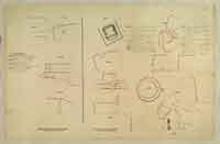
Plate 2. Plans And Sections of Several Small Excavations in The Rock of Kalinjar
Pen and ink and wash drawing by Frederick Charles Maisey of plans and sections of several small excavations at Kalinjar, from an album of 60 drawings dated 1847-1854. The drawing is inscribed: Fig.1, 2. 'Siddhon ke Gupha.' Fig. 3, 4. 'Bhugwan Sej.' Fig. 5, 6, 7. Plans and sections of small cave below the Nilakanth. Fig. 8, 9, 10, 11. Plans and sections and details of 'Bulkhun di Mahadeo.'Situated atop an almost impregnable 1000-foot-high hill, with cliffs on all sides, Khalinjar was an ancient Chandella stronghold from the 9th to the 15th centuries; it was later conquered by Akbar in 1569 and fell to Colonel Martindell in 1812. Within the fort there are numerous archaeological remains.
Courtesy: Europeana.eu- Anonymous's blog
- Log in to post comments