Study on Bundelkhand of Planning Commission: Introduction - Geographic Features.
Study on Bundelkhand of Planning Commission: Introduction - Geographic Features.
Geographic Features.
1 Physical Characteristics.
Madhya Pradesh (MP) is the largest state in the country with a geographical area of 4,43,446 Sq.Kms. It is a hill-locked state between the latitudes 170 46’56” and 260 52’40” North and the longitudes 740 0’55” and 840 23’54” East of Greenwich. It is situated in the middle of the country and is bordered by seven states namely UP, Bihar, Orissa, Andhra Pradesh, Maharashtra, Gujarat and Rajasthan. What is peculiar about MP is that it is one of three interior states of India, the boundaries of which neither touch sea nor any international border. It is the state which divides the fertile Gangetic plains of UP in the north from the broad tableland of Deccan Plateau. MP is the state of low hills, narrow valleys, plateaus and plains. Geographically, MP can be divided into four regions:
1. Northern mid-high regions which is a large triangular mountainous area averaging 300-400 metres above sea level and comprises of Vindhyachal, Malwa and Bundelkhand hilly area.
2. Narmada valley which has the extent upto Son river valley in the northeast and the Gujarat border in the west and is very fertile.
3. Satpura mountains which extend 600 km between the Narmada and Tapti rivers and
4. Eastern hilly region which comprises of the hills of
Baghelkhand, the Chhattisgarh plains, Dandakaranya and the high altitude hills
of Bastar. MP contains high altitude Satpura mountains (1350 metres) on one hand
and the low-level ravines of Chambal valley (150 Mt.) on the other. The major
rivers of MP are Narmada, Mahanadi, Chambal, Ken, Son and Betwa . The rivers
Narmada and Tapti have the peculiarity in the sense that they drain the water of
Satpura and Vindhyachal mountains westward towards the Arabian sea.
The Western part of MP is fertile with black soil. Eastern MP is a less fertile
area with red and yellow soil. The northern part of the state has the mixture of
both of these soils. The mountainous high altitude region contain laterite soil.
MP has the second largest forest area in the country, next to Orissa. Almost one-third of the State is forest area, compared to one-fifth for all India.
The districts which are the part of the present study, mostly
fall within the Bundelkhand hilly
areas which is the part of the northern mid high regions of MP. The district
Santa is the part
of Baghelkhand region which is also a hilly area, bordering the Bundelkhand.
The Bundelkhand and Baghelkhand regions of MP are rocky and has a high percentage of barren and uncultivable land. The soil form is the mixture of black and red-yellow which is not considered very fertile. Rainfall is sparse and the agricultural production is low. Poverty level is significantly high .
Though, MP is rich in forest, Bundelkhand has lost its forest cover to a large extent.So, the forest as a means of livelihood is becoming extinct day by day. Mining of minerals and stone-quarrying has emerged as a major non-form activity but is based on exploitative wage labour.
2 Location/boundaries :
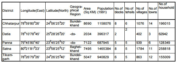
Location of the districts Datia, Tikamgarh, Chhatarpur, Panna and Satna together forms a half-circle in the northern-MP. Among all these districts Datia forms the north-west part while Satna is in the east. Datia is little cut-off by a trench of UP while other four are locked together.
District Datia, the smallest of all in MP, is the part of Gwalior division and is surrounded on the north and east by Bhind, on the west by Gwalior and on the south by Shivpuri and district Jhansi of UP Tikamgarh, situated towards the west to the centre of plateau of Bundelkhand is surrounded by district Jhansi of UP in the north and Lalitpur(UP) in the west and south. So Tikamgarh is covered more by the parts of UP than that of MP. Towards its east, district Chattarpur is situated. People of Tikamgarh have constant and regular interaction with the cities of UP namely Jhansi and Lalitpur for their daily affairs.
For Chhatarpur, rivers Ken and Dhasan form the physical boundaries on the east and west respectively. This district is surrounded on the north by district Hamirpur (UP), on the south by Damoh, on the east by Panna and on the west by Tikamgarh. The rivers Ken and Dhasan separate the districts, respectively from Panna in the east and Tikamgarh in the west.
Panna, a district with a high concentration of forest, is surrounded in its north by Banda (UP) and some parts of Satna district, in its west by Chhatarpur and Damoh, in its south by Jabalpur and in its east by Satna district.
District Satna, a part of the Rewa division, has its northern boundaries completely covered by the districts of UP. On its west, Panna is situated while its east is covered by Rewa and Sidhi. Its southern boundaries are touching the districts of Jabalpur and Shahdol.
Districts under study
3 Climate, rainfall and seasons.
It is a varied climate in MP. The northern districts of Gwalior, Bhind, Morena, in particular and the whole of Bundelkhand is very hot during the summer. Winter in these areas is severe in general. The south-eastern districts- Raipur, Bastar, Bilaspur and Chhindwara - are also very hot. The climate of the western part of the state is moderate.
The monsoon comes from the southwest in mid-June and ends in mid-October. The average rainfall of the state is about 900 mm. The districts normally Raigarh, Bilaspur, Surguja, Shahdol, Raipur, Mandla and Balaghat receive high rainfall.. Winter rainfall is infrequent but important for rabi crops such as wheat, gram, barley and oil-seeds which are the backbone of agricultural economy of the state.