REGIONAL DEVELOPMENT ANALYSIS OF BANDA DISTRICT : Satyam Tripathi, JNU
REGIONAL DEVELOPMENT ANALYSIS OF BANDA DISTRICT
- Satyam Tripathi, JNU
INTRODUCTION
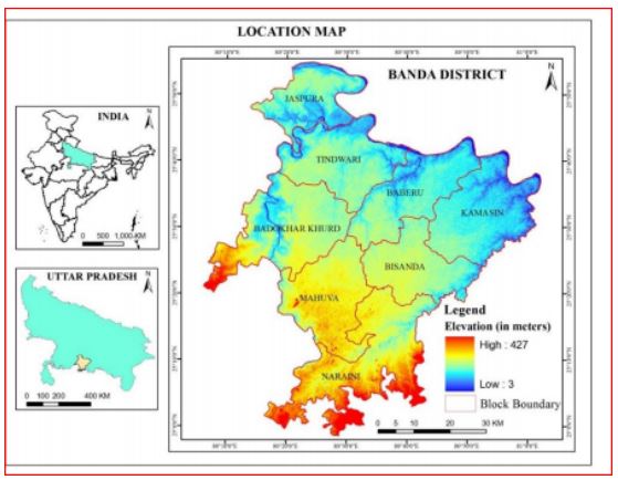
The City of banda is situated on the side of river ken .Its main development is seen only in one sides of the river .The total geographical area is 4456.802 km2 and the altitude varies between 3 to 427 m. It is extending from north to south is about 104.60 km and west to east is about 94.50 km. It is situated in Fatehpur District (U.P.) northeast, Hamirpur District (U.P.) northwest, Mahoba District (U.P.) west, Chitrakoot District (U.P.) southwest and Madhya Pradesh (State) south and southwest .Banda is a district of Uttarpradesh which lies in the Bundelkhannd region . District Banda comes under division ChitrakootDham which was constituted in the year 1997.In the year 1997 Banda district has been divided into two districts namely Banda and Chitrakoot. To provide efficient administration the district is administratively divided into 04 tahsils namely Banda ,Naraini , Baberu and Atarra. For implementation and monitoring of development scheme the district isdivided into 08 Development Blocks namely Jaspura, Tindwari, Badokhar Khurd, Baberu, Kamasin , Bisanda, Mahuva and Naraini. Total area of the district is 4408.0 Sq. Km. The rural area covers4347.7 Sq. Km. and urban recorded 60.3 Sq. Km. There are 437 Gram Panchayats and 694 Revenue villages with 657 inhabited villages and 37 uninhabited villages in the district. In urban area there are08 Statutory Towns. Statutory Towns comprises of 02 Nagar PalikaParishad and 06 Nagar Panchayats. Banda district has a urbanization Of 15.3% which is even below the average of state 22.3 %.Banda district has a population density of 408 person /sq.km which is half of the state average of 829 person /sq.km .In district of Banda the sex ratio is in very dismal condition which is 863 female per 1000 of male population .Literacy is 66.7 % which is 1% low below the state average of 67.7%..The decadal growth rate of population is 19.8% which is below the state average of 20.2%.
BRIEF HISTRORICAL BACKGROUND OF THE DISTRICT
The district is named after the headquarters town, Banda, which is said to have derived its name from Bamdeo, a sage mentioned in Hindu mythology as a contemporary of Rama. Bamdeo is said to have had his hermitage at the foot of a hill later called KhutlaBonda, the name by which a locality of the town is still known. The first glimpse of the early history of the district is obtained from stone arrowheads and other implements discovered in 1882 AD at various places in the district. Specimens of Neolithic tools, rough sketches of birds, beasts and human beings have been found in this region. Pebble tools and low hand axes have also been discovered in this district. In prehistoric times this region seems to have been inhabited by primitive people like the Bhils and Kols.The earliest known Aryan people associated with this region were the Chedis whose king, KasuChaidya who is said to have made a gift of ten kings as slaves to his priest, was praised for his liberality in a "Dana Stuti" found at the end of a hymn in the Rigveda.. It was due to activities of these Chedis, who are said to have had one of the most ancientlineage among the Aryan people of India, that this region was brought under the Aryan way of life.About the middle of the fourth century B.C., this region was annexed to the Nanda Empire ofMagadhaThe end of Kushanarulesynchronized with the emergence of Nagas who succeeded in capturing Padmavati, Mathura, Vidisa,Kantipuri and its surrounding regions. The most important Naga rulers who ruled over this regionwereBhavanaga, Ganapatinaga and Nagasena but were conquered and ousted by the Gupta emperor,Samudragupta about the middle of the fourth century A.D. As a result this region passed into the hands of the Gupta monarchs and continued to be a part of their empire till the beginning of the sixth century. When king HarshaVardhan (606-47 A.D.) established his supremacy in north India, the region was included in his dominion nd it was during this period that we get first historical notice of Bundelkhand. The most mportant event of Dhonga's reign was the final severence of all connections with the Pratiharas. About 1017 AD. Sultan Mahmud attacked the Pratihara Kingdom of Kannauj and compelled its ruler Rajyapala to enter into a humiliating treaty, including recognition of Muslim supremacy. Throughout Aurangzeb's reign the area covered by the present district formed part of the suba of Allahabad but in 18th century the Bundelas took Kalinjar and Chhatrasal, their leader, was recognized by the Mughal Emperor Bahadur Shah (1707-1712 A.D.) as ruler of Bundelkhand. The present district of Banda was ceded to the British by the treaty of Basscin in 1803. British administration began with the arrival of Captain Baillie, agent for political affairs in Bundelkhand. The growing discontent of masses was two measures namely, the land revenue settlements and the annexation of Awadh. On June 8, 1857, a large number of prisoners who had escaped the central jail at Allahabad crossed over to Mau in the east of the district and excited the people to action. Government property was destroyed, buildings gutted, a treasure containing rupees was plundered and even the records of the court were destroyed. By February 1858, the revolutionary flame was in full blaze and the popular character of the freedom struggle was manifested. But the fire of revolution was extinguished completely by British on 6th June 1858.After 1858 a new feature began to appear in Banda. Trade and commerce began to grow owing to the constructions of the rail and road. During the close of the 19th century the activities of Arya\Samaj led to great social upheaval among the backward local populace. A campaign was launched in the district for using indigenous goods, especially Khadi or homespun cloth. Mahatma Gandhi, Sarojini Naidu and Acharya J.B. Kripalani were on a hurricane tour of whole of the Northern India in order to gathersupport for the newly launched Civil Disobedience Movement after the failure of Simon Commission. They came to Banda in November 1929. In 1930 Civil Disobedience Movement was started in Banda, along with the rest of the country. The first phase of the movement comprised violation of the salt Act. Congress volunteers and other people of the district responded by manufacturing contrab and salt at Dus Maidan near Karwi. During the Second World War the people of the district started amassivecompaign against the war fund. In 1941, thousands of congress members as well as other people of the district launched Individual Satyagraha against the war fund campaign and courted arrest.
Population
1. Population growth and distribution
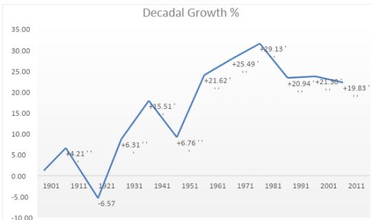
The growth of population in Banda in period 1901-1921 shows negative growth rate due to the effects of famine, cholera and plague in North India generally and in this region particularly. The period 1921-1941 marked gradually increasing growth rate but not very high. The period 1941-1971 noted stagnant and relatively low growth rate as can be seen in graph which is almost horizontal showing a constant growth rate. In the period 1971-1981the growth rate increased drastically from about 25.49 to to 29.13 i.e. nearly doubled. From 1981 to 1991 the growth rate remained high but it came down significantly in 1991 to 20.94 but after that it was more or less constant in 2001. From 2001 growth rate of 21.30 ,it came down to 19.83 in 2011 which was very minimal change witnessed in 2011. This was due to the stagnancy of birth rate .
Table 4. Decadal growth rate of population in Banda district, 2011.
The district comprises of total 319963 households. The number of households is much greater in the rural area compared to urban areas. Of the total household 85% of the household are rural where as the remaining 15% households are urban. Only 0.2% of the households are institutional showing that the District is devoid of institutional activity
The average household in the district is 5.6 which is even less than the average household size of the State which is 6. The rural and urban areas have nearly the same household size, even in urban area is very slightly low. This is because the urban areas of Banda district are devoid of any industrial town and hence workers and labors not migrate here to work and stay in a congested household, so that household size can increase.
3. Age-sex structure
About 36.4% of the population of Banda is under young-age dependents (0-14 years of age) which is very high, and 9% of the population are old-age dependents (60 years and above).
The age-sex pyramid shows that there are more percentage of males than females in the young age group, signifies the preference of boys over girls and the issue of female feticide. Also the over-all male population is slightly greater than female population in the entire age group except the age group between 25-39 years. This shows that the males in this age group of 2539 years emigrated for job opportunities and for workings in informal sectors of other large cities of India and abroad.
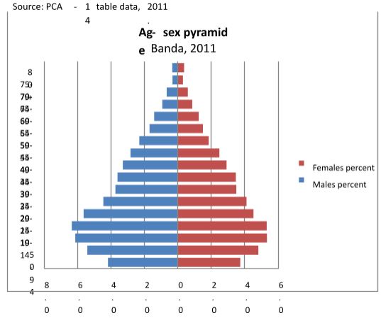
The base of the pyramid is wide and the top is narrow and looks like Rapid Growth Pyramid.The narrower top of pyramid shows that the death in old age is high where as the wide base shows that birth rate is very high and also comparatively less population in the age group 0-4 years shows that Child Death Rate is high.
The age-group 0-4 years shows the less number of children due to the child death rate and also due to decreasing fertility to some extent. This may further continue and then the pyramid will become bulge in the middle showing the demographic dividend, in future decades. The population pyramid shows that the dependency ratio is very high.
Sex Ratio
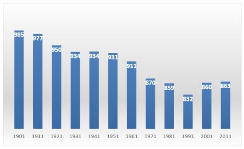
The sex ratio of Banda district is 863 (in 2011) which is less than the state average which is 912.The sex ratio in 1901 was very high i.e. 985 females per thousand males which reduced drastically in the next decade as shown in the trend bar graph. This shows that the famine and epidemics of very early 20th century affected the females most than males. The sex ratio decreased from 985 in 1901 to 832 till 1991. After 1991 it again started increasing little bit as can be seen in the graph. This can be seen as the impact of liberalization that people start gaining education,but still it is very low. Due to this most of the men are bachelor here and not able to marry and find brides. Unemployed persons are generally unmarried here.
The child sex ratio is very low as can be seen through population pyramid, i.e. there are less number of females born in the age-group of 0-4 years compared to the male population in the same age group, showing the preference of boys over girls.
4.2. Literacy
Average literacy rate of Banda in 2011 were 66.67% compared to 54.38% of 2001. If things are looked out at gender wise, male and female literacy were 77.78 and 53.67 respectively. For 2001 census, same figures stood at 69.28% and 36.78% in Banda District. Total literate in Banda District were 1,002,937 of which male and female were 630,626 and 372,311 respectively. In 2001, Banda District had 670,986 in its district. Literacy rate in rural area is 64.16% and urban area is 79.85%. There is not much difference between male literacy of rural and urban but female literacy is very low in rural areas i.e around 50% as compared to urban areas i.e around 71%. Female child is generally not imparted with education that is the reason of overall low literacy of female in the district.
5. Economic Characteristics:
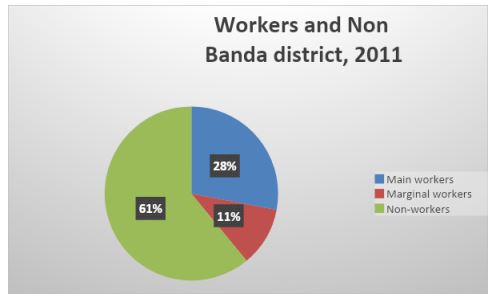
In the Banda district there is about only 39 % working population of the total population whereas the remaining 61% of the population is non-working. The working population is categorized in to main and marginal workers based on either they worked throughout the year or less than six months (180 days) in a year, respectively. Out of 39% workers about 69% are main workers whereas remaining 31% are marginal workers. Total population ha share of main workers, marginal workers and non-workers as 28%, 11% and 61% respectively.
The workers are also categorised by four-fold industrial classification based on the type of work they perform. In Banda district out of the total workers (main + marginal) there are 29% cultivators, 30% agricultural laborers, 6% household industry workers where as remaining 35% workers work in other categories. This signifies that majority of working population about two third is engaged in agriculture related activities and small household industries.
Also the sex-wise distribution of workers shows that out of total male population 43.6% males are workers where as out of total female population only 22.4% females are workers. Out of total ain workers men contribute about 55% whereas women contribute only remaining 45%. Similarly in the marginal workers category female contribution is relatively high around 50% . Also in urban population there is less percentage of total workers compared to rural population.
Only 27.6% of the urban population is working where as in rural area 33.7% of population is working. In urban areas out of total working population there, 81.2% are main workers and remaining 18.8% of workers are marginal. But in the rural areas out of its total working population 62.5% is main workers and remaining 37.5% is under marginal workers.
RESOURCES
Soil
In Banda district loose sediments as well as black cotton soil is found. Black cotton soil is prominent in the central part. Four major type of soil : a) Rakar, b) Mar, c) Kabar and d) Padua are dominant in the district.
Agriculture resources
The three main cropping seasons in the district are Kharif, Rabi and Zaid. The other crops raised in the district include wheat, paddy, maize, pulses and oilseeds. Main fruits grown are mango and guava.
Minerals
There are ample of minerals in the district like Bauxite, Granite, China clay and Dolomite. These mineral can be used as raw material for various industries.
Forest resources
Forest cover is very less in Banda. Forest is found only 1.9% area which varies from one block to another blocks Tindwari, Mahuva and Naraini are the blocks where 2.48%, 2.58% and 6.61% area is found under forest covered besides this all the block have less than 1% forest cover land.
LAND-USE PATTERN
Land surface resources display the scenario of the resources of an area. Banda district which is located at Bundelkhand plateau. The land resource is mainly governing by the agricultural land because of availability of water and compatibility of soil to grow the crops. agricultural land is major land use category which occupied about 83.37% of district. The land use land cover scenario changes one block to another block in the district due to the terrain characteristics and drainage system. It is experienced that Banda district has more agricultural land (83.37%) in percentage in comparison to state average (79.23%). Banda district has 8 block viz. Jaspura, Tindwari, Badokhar Khurd, Baberu, Kamasin, Bisanda, Mahuva and Naraini have area 7.08, 10.62, 9.89, 8.74, 13.04, 11.74, 14.93 and 10.38 percentage of area respectively. Jaspura and Mahuva are the smallest and biggest blocks in respect to area of the district. Agriculrural Land Banda is rural population concentrated district where 84.68% population inhabited in rural areas, which is greater than the national and state average (Census of India, 2011). Only 15.32% population lived in urban areas. All the rural population depends upon the agricultural land which occupies about 88.77% area of the total land of the district. Kamasin, Bisanda, Mahuva and Naraini blocks is more than 85% area included in agriculture. While Tindwari, Badokhar khurd and Baberu blocks are about 75% to 85% area implies in agricultural land. Jaspura is the only block, where about 62.52% area falls under this category of land. Barren Land This area is mostly associated with stream coarses and its proximity areas of the district. In these areas riverine sent can be seen that accumulate during the flooding time. Those blocks in the proximity of rivers have large area of this type of land viz. Jaspura, Tindwari, Badokhar Khurd, Baberu, Mahuva and Naraini are the blocks have more than 5% barren land. Jaspura and Badokhar Khurd is largely suffering with growing this type of land due to flooding and water logging during the rainy season. Forest In Banda district forest is found only 1.9% area which varies from one block to another blocks Tindwari, Mahuva and Naraini are the blocks where 2.48%, 2.58% and 6.61% area is found under forest covered besides this all the block have less than 1% forest cover land. Mainly in southern part of the district where some ranges of Vindhyan mountain range passes that is why some patches of forest found there. Waste Land The land resultant of the terrain deformation due to water erosion which occurs widely in the areas associated with stream courses. Gullies are formed as a result of localized surface run-off affecting the unconsolidated material resulting in the formation of perceptible channels causing undulating terrain. After some time this land convert into degraded land. In Banda district about 1.75% area found in this type of land, which is mostly found in the blocks associated with river courses in Baberu where about 12.07% area found independently in this land. Jaspura, Tindwari, Badokhar Khurd and Kamasin blocks are falls 0.75, 0.92, 0.38, 0.40 percentage areas in these categories respectively. River Bodies The district encompassed by the rivers from the three sides of the district, occupy about 2.67% area of the district inclusively. The district is about quadri-lateral in shape. Yamuna River flows from west to east in the northern direction. Baghain and Ken Rivers, sub-tributaries flow from southwest to northeast direction in the district. Settlement & Built-up Area Banda district is rural population dominant district where about 77.7% rural and 22.3% urban population inhabited subsequently. In the district about 1.11% area included in built-up area which is varies from block to block. All the block except Mahuva and Naraini have more than 1% area of built-up land which less than state average (1.73%).
OBSTACLES OF THE DISTRICT FOR DEVELOPMENT
SOCIAL DEVELOPMENT: Social development of this district is very poor. This can be seen from the fact that sex ratio is very less in district i.e. 853 females per thousand males which is even low than the state average of 912. This signifies the pathetic conditions of women in Banda district. It shows the infanticide and people are averse to provide them education. Due to the low sex ratio, most of the males are unmarried. Female labour force participation rate has reduced from 34.4% in 2002 to 28.5% in 2011. There is change of participation of women conditions in the district which shows the reduction in women status. Women literacy is also very low in the district i.e. 53.67% which further shows their lamenting conditions.
Crime Rate: Crime rate is very high in the district i.e. 93.64 for the year 2018. That can be because of high unemployment rate that leads to switching over to crime, theft etc.
Health status: Heath conditions of the people are very dismal due to low availability of medical facilities in the district. Health relates infrastructure is very weak as there is low number of hospital beds per 1000 people, lack of advanced machines for different kind of tests. There are only five government hospital in the district namely District homeopathic hospital, Government ayurvedic college and hospital of Attara, Banda, Government Hospital Civil Lines Banda,Government Medical College Naraini Banda and Government Veterinary Hospital Banda.
Education status: There are only seven higher education institutes for the students to study. Attara post-graduate college ( Attara, Banda), Banda University of Agriculture ans Technology, Government Ayurvedic College and Hospital ( Attara, Banda), Government Medical college (Banda), Gvernment girls inter college, Pandit Jawahar lal Nehru Post-Graduate college ( Civil lines, Banda), Rajkiya Mahila Snatkottar MahaVidyalaya (Banda).
ECONOMIC DEVELOPMENT:
Per Capita Income: Per capita income is very low in the district. Since most of the people are employed in agricultural sector, per capita income of the district is 36,320. Due to this most of the people are out migrating from the district.
Financial and Banking Service: Financial banking services are very low. There are only three Sate Banks of India and people are not aware of the finance related activities. Dominance of Agriculture: In Banda district, most of the people are employed in agriculture and agriculture is unprofitable for the people, due to the less productivity of the agriculture sector and dominance of cereals. People are not able to transport the agriculture produce due to poor supply chain management and lack of affordability of the farmers.
Minimal number of Industries: There are very few industries in the district which shows low level of Industrialization and lack of utilization of available mineral resources. Even agro-based industries have not been developed so far. There is scope of dairy farming in the district but it is also lagging behind. Only few industries are there which are located in Bhuragarh Industrial Area.
Mining in region mining takes place in ken river and also in ken river .sand mining and morum mining in banda takes place .various sand mining projects are working in banda region .
TRANSPORT CONNECTIVITY
In district of banda , there is less connectivity related to transport of network .
Road Transport There is not all weather road connectivity in the district with respect to movement from villages to the city .In Banda people cannot get vehicle to go to their villages after evening ,and the cost of movement is high due to plateau and rugged terrain so mobility is affected by this .
State Highway NH-35 ,this is a highway which runs entirely in Uttarpradesh ,this route goes through the district of kabrai(Mahoba),Banda,Karwi,Mau, Allahabad ,Mirjapur,Varanasi.This is the highway which is not connected to the villages with metallic road, leading to its not use of by the district as a whole .
Railway Transport In terms of connecting with big cities ,less number of trains are available for travelling for example Bundelkhand Express ,Mahakaushal express ,Sampak kranti ,these are the few trains which are available .On daily basis these trains are not available . So it can be said that road connectivity is much poor in terms of availability of vehicles ,road condition as compared to rail.
DEVELOPMENT MODEL
Ragnar Nurkse Development Theory
He has hypothesized that the major obstacles to development of the underdeveloped region is th vicious circle of poverty. This vicious circle of poverty shows that income in underdeveloped region is very low. Due to this low income people are having low savings. Due to this the amount for investment which is left behind will leads to low production. As a result, this will produce low income and employment. Since there is no impetus, smaller markets will be created. Since people are having limited income, so firms and industries are averse to development. Government is also indirectly not keen to develop because revenue will be not generated because of low income of the people. Since per capita income of Banda district is around 36000, so people are having low purchasing power, so they are not able to buy goods and services that restricts the possibility of development. Vicious circle of poverty is affecting the development of the district from demand side as well as supply side.Nurkse was of the view that government should intervene in productive activities through economic planning. By providing skills and employment opportunity to the youth, income of the youth can be increased which will be helping in breaking the vicious circle of poverty and as far as supply side measures are concerned government should heed on small scale industries which can be developed in the district. In this regard, we can observe that in Banda, Bhuragarh industrial area and agro based industries are not working.
W.A. Lewis Theory on balanced growth
In Banda district, agriculture is dominating since most of the people are engaged in agriculture activities and development of industries are very negligible. Lewis was of the view that in economic development of the region balanced approach should be followed. Focusing on one sector will harm the economy so interlinking between agriculture, industry and services is required. In this regard we can see that Industrial growth is missing in the region. It can also be identified that Shazar Stone which is very precious and can be used in making ornaments is lagging behind in the region and their workers are facing intractable problems.
CONCLUSION
Banda is one of the backward districts of India in Bundelkhand region. This region is having the potential of development but due to negligence in respect of proper utilization of available resources is making this district backward. Agricultural profitability is very low and its productivity is very low, making agriculture sector incompetitive in terms of sustaining the livelihoods of the people. To forestall the situation not sustaining in agriculture, generally people used to have cattle for milk production but due to the lack of dairy industry the region and its potential has not been utilized. Roads are not connected to the highway in a proper way which is restricting the mobility and also it is distressing thing for labourers to commute daily to earn wages. Banda also has the potential of utilizing Shazar stone and several other mineral which can be used as raw material for various industries. Unabated and unregulated use of sand mining is a major issue in the district. By proper policy measures and strategies the development of Banda district can be realized.
REFERNCE
1. NGT Seeks Centre’s reply on sand mining in UP Banda district,Business standard newspaper, January 24, 2017.
2. Primary Census Abstract (PCA) data, 2011.
3. District Census Hand Book (DCHB) Part A & B of Banda, 2011.
4. Kumar, S. (2017). Remote sensing and GIS based analysis of land use land cover and soil fertility status at inter-block level in Banda District of Uttar Prades. ResearchGate.
5. Das, A. and Mandal A. (2020). Assessing the level of living condition in Bundelkhand region of Central India: a households level analysis. SpringerLink.
6. Bass, H. (2009). Ragnar Nurkse Development Theory: Influence and Perceptions. ResearchGate.
7. Website : www.banda.nic.in
About Author : Satyam Tripathi is studying in Centre for the Study of Regional Development (CSRD) Jawahar Lal Nehru University(JNU), New Delhi pursuing masters from geography. He has graduated from University of Allahabad.
- admin's blog
- Log in to post comments